When people start talking about Assam, they only seem to talk about tea and floods; monsoon rains bring even a little more. They don’t remember how the train connection has always been there to keep the entire region together. Travelers only really realize it when they’re stuck in between Rangiya and the river crossing point. About 1,320 railway kilometers of Northeast Frontier Railway connect across eight states covering part of the eastern and northeastern frontier states.

It traverses such treacherous terrain that Indian Railways, anywhere else, hardly sees. The whole populace relies on the trains in a way flights and roads cannot offer. It’s about the headquarter, the divisions that split the job, and the characteristics that make this railway division different from seventeen others. This aspect of the zone shows just how the people in the North-east remain connected.
What Does NFR Stand For
Type “nfr full form” into Google and the answer arrives fast. Northeast Frontier Railway. One of eighteen zones under Indian Railways, and by land area, the largest of them all. Ask about nfr full form in railway terminology and you get the same zone, same answer, just phrased differently by whoever’s searching.
Confusion tends to creep in around the naming though. Some passengers search “north frontier railway,” others type “north east frontier railway,” half expecting these to be separate railway bodies. They aren’t. Every version circles back to one zone: Northeast Frontier Railway, shortened to NFR railway on tickets, timetables, and station boards across the region.
1958 is when it all began, formed by pulling together railway lines that had been scattered under separate administrative arrangements before that. Train connectivity in the northeast existed in pieces prior to this merger. Consolidating everything under one zone changed how the region could actually be served, though calling it efficient depends heavily on which stretch of track you’re standing on during monsoon.
Northeast Frontier Railway Headquarters
Guwahati runs the show. Specifically Maligaon, a locality that has become nearly inseparable from railway administration across Assam. Spend any time in Maligaon and the railway presence becomes obvious fast: colonies, workshops, trains constantly being serviced or dispatched somewhere down the line.
Why Guwahati and not somewhere else? Geography decided this one, not convenience. Assam is known for opening a pathway to the rest of the northern states and that’s why Guwahati has been identified as the only place which makes coordination of operations across a stretch from West Bengal to Arunachal Pradesh actually possible. The head office is responsible for things like the planning of work, safety policies, execution of the physical and tangible parts of the projects, inter-departmental cooperation which involves departments working in radically different environments: all of these are areas that it oversees.
Also Read: Exploring Western Railway: From Business Hubs to Beaches
One of NFR’s major workshops also sits in Maligaon. Here, a large share of coaches and wagons maintanence goes on. This isn’t a building full of officials shuffling paper. It’s an operational hub that keeps trains moving across the entire zone, and locals in Guwahati have started calling job transfers within NFR simply “Maligaon postings.” Says something about how deep that headquarters runs into local identity.
Divisions Under Northeast Frontier Railway
Five divisions carry the operational weight here, each covering a stretch of territory unlike the next. Alipurduar Division handles the West Bengal side, working through the Dooars region before connecting into Assam. Katihar Division stretches into Bihar too, which catches people off guard since most assume NFR maps neatly onto northeastern states alone. It doesn’t.
Rangiya and Lumding divide most of Assam between themselves. Rangiya is mostly responsible for the Guwahati-bound routes whereas Lumding is concerned with the hill sections leading toward Nagaland and Manipur. Tinsukia Division goes farthest in the east, providing services to Upper Assam, also extending into Arunachal Pradesh.
Think of each division as running almost like its own small railway system, dealing with problems specific to wherever it sits. Landslides and steep gradients define Lumding’s challenges. Tinsukia contends with thick forest cover and elephant corridors that genuinely control how fast trains can move through certain stretches. Katihar faces flooded plains once monsoon arrives.
Why divide things this way at all? A single administrative approach was never going to work across terrain this varied. Whatever works on flat plains near Katihar would fall apart entirely in Lumding’s hill sections, so each division operates with a degree of independence within the wider northeast frontier railway zone.
Northeast Railway Map and Coverage
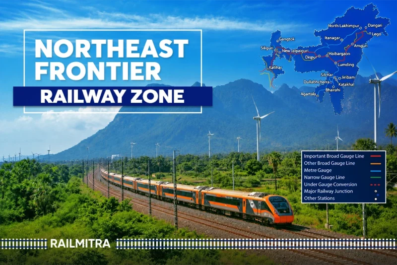
Pull up a north east railway map and the scale of NFR hits you immediately. Assam, West Bengal, Bihar, Nagaland, Meghalaya, Tripura, Mizoram, Arunachal Pradesh: all under one zone, a spread most people don’t grasp until they see it laid out.
Nothing about the route pattern resembles a neat grid the way parts of North India do. Lines follow river valleys, curve around hill ranges, often taking longer paths simply because straight lines aren’t physically possible through this terrain. The Brahmaputra with its tributaries continuously influence route planning by requiring bridges and detours that extend journey times a whole lot beyond the map’s suggestion.
New Bongaigaon, Guwahati, and New Jalpaiguri are the main junctions which multiple railway lines meet, making them the central points on any map of the North East Railway. Even today, some capitals cities have limited direct connections and That’s why trains heading towards Mizoram or far corner of Tripura make a stop at these junctions en route.
Unique Features of Northeast Frontier Railway
Certain things set this zone apart from the rest of Indian Railways entirely, details passengers rarely pick up on unless they’ve travelled through repeatedly.
Elephant corridors dictate operations
Stretches around Tinsukia and parts of Assam pass directly through known elephant migration paths. Trains slow down, sometimes stop entirely, when herds are nearby. NFR has installed early warning systems in the highest risk zones specifically to avoid collisions.
Monsoon vulnerability shapes scheduling
Flooding and landslides aren’t rare disruptions on this network, they’re built into the operating calendar every year. Dedicated disaster response teams stay ready, and relief material often gets pre positioned ahead of peak monsoon months.
Bridge density runs unusually high
Crossing the Brahmaputra system and its tributaries demands far more major bridges than most other zones need, several of which count as genuine engineering landmarks that took years to finish.
Gauge conversion history runs deep here
Large stretches operated on metre gauge for decades before broad gauge conversion arrived, and traces of that older network still shape certain station layouts today.
Strategic relevance stands out too
Sitting close to international borders with Bhutan, Bangladesh, and China gives several NFR routes a defense logistics significance that goes beyond ordinary passenger transport.
Cultural diversity along a single line is hard to match
Few railway journeys anywhere in India shift language, food, and landscape as dramatically within a few hundred kilometres as a typical NFR route does.
Checking Train Schedules on RailMitra
Planning a trip quickly is not easy. However, using RailMitra makes it easy without complecating it. The train schedule tool pulls up complete timing details for any NFR train, departure times, halting stations, expected arrivals, all without passengers hunting through half a dozen sources.
NFR routes stay weather dependent in a way most other zones don’t have to deal with, which makes quick schedule access matter more here than almost anywhere else. Someone travelling toward Tinsukia or Lumding during monsoon benefits from checking timings close to departure rather than trusting information pulled from weeks earlier, since revisions happen often on these particular routes.
Trains Between Stations and Live Status
There’s also a trains between stations feature on RailMitra, useful when passengers can’t quite figure out which train actually connects two points across this sprawling zone. Five divisions branching every which way makes this tool genuinely save time, especially for anyone unfamiliar with which junction leads where.
Once the booking’s done, live train status becomes the tool that matters most. Landslides, flooding, elephant related halts: NFR routes see delays from all three, so tracking a train in real time beats relying on the original schedule, and it keeps passengers from standing around at stations for no reason. RailMitra pulls this data directly from railway feeds and updates it regularly.
Booking Food During Your Journey
Long hauls through NFR territory, especially anything stretching toward Tinsukia or the hill sections near Lumding, can run for hours without a proper halt at a major station. That’s the exact gap RailMitra’s food delivery service fills, letting passengers order meals that show up right at their seat during a scheduled stop.
This matters more here than it does on busier North Indian routes. Food options at smaller stations across Assam, Nagaland, or Arunachal Pradesh tend to be thin compared to what’s available on higher traffic lines, and families or overnight travellers usually prefer a meal ordered in advance over gambling on whatever the platform happens to offer. RailMitra’s food delivery network covers a wide spread of NFR stations, which makes it one of the more genuinely useful tools for anyone travelling this region often.
Conclusion
Not many railway zones in India run under conditions quite like this one. Elephant corridors, monsoon disruptions every single year, a geographic spread across eight states, five divisions each built for terrain that has nothing in common with the next: the Northeast Frontier Railway carries far more weight than most passengers realise.
Whether the search started with nfr full form for a school assignment or an actual trip being planned through Assam and beyond, understanding how this zone works, where the headquarters sits in Maligaon, how the five divisions split the load, all of it paints a clearer picture of how the northeast stays connected at all. And with RailMitra handling schedules, live status, and food along the way, getting through this network has gotten a lot less complicated than it used to be.
Read More: East Coast Railway Zone: Headquarters, Divisions and Guide
Read More: Best Railway Station in India: Complete Updated List 2026